 The route from Cambridge, MA to Cambridge, VT isn’t quite as simple as it was for my NY and Maine visits when I could drive U.S. highways almost all the way, but it’s still not too complicated. Despite continuous rain in New Hampshire, the skies brightened after I crossed the border into VT. Once off Route 89, I went through Waterbury and Stowe (useful for context on the ski world). Cambridge, VT is about a half hour northeast of Burlington, and about the same distance from the border with Canada. There might be a stoplight in town, but I never saw it.
Both coming and going, I drove through Smuggler’s Notch, a mountain pass that is closed in the winter and that separates Stowe from Cambridge. I would describe the road as a series of sharp turns separated by short stretches of straightaway, until it gets serious and it’s one hairpin turn after another. I stopped a few times for the scenery on the trip home. Here’s the point that turns out to be the highest on the road.

I mentioned a couple of posts ago that I was trying to focus my visits on places with a clear “Cambridgeness.” Cambridge, VT is somewhat complicated in that regard. The Town of Cambridge includes two incorporated villages, Cambridge and Jeffersonville, but most of the population of the Town isn’t included in a village.
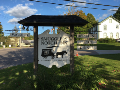
I stayed in Jeffersonville’s historic Smuggler’s Notch Inn (dating to 1790), but I made sure to visit the center of the Village of Cambridge, too. Both areas have stores that sell the essentials and several people told me that they depend only on the local shops when they can’t or don’t want to travel to supermarkets in other towns.
Vermont is, in general a super-scenic place, between the mountains and the old New England towns. Here are a few pix from the trip.


One thought on “The road to Cambridge, VT”